- Streamlined interface
Your Price:$249.99/ Each
Availability:
1 Remaining In Stock
Ships immediately
This item is no longer produced by the manufacturer. Limited quantity is available.
Description
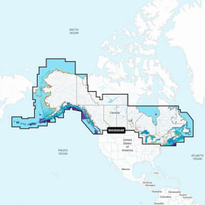
Canada, Alaska, & Great Lakes - Lakes, Rivers and Coastal Marine Charts.
IT’S A WHOLE NEW LOOK ON YOUR CHARTPLOTTER
Featuring vibrant colors, a streamlined interface and combined coastal/inland content with a popular Navionics® style color palette, Garmin Navionics+ cartography makes it easy to plot your course with the world’s No. 1 name in marine mapping1.
Specifications
MFG #:010-C1288-00